
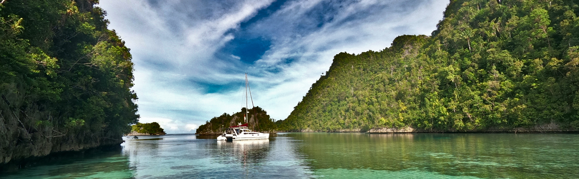
Raja Ampat is one of the best dive locations on the planet, with vibrant corals growing in clear tropical waters along steeply fringed karst rock islands. This area of Indonesia is scarcely populated, with the local villages typically living a subsistence lifestyle on fish and vegetables. Tourism is growing, with many locals working in “homestay” accommodation, or looking to work as guides for visitors. Literally meaning “four kingdoms”, Raja AMpat is made up of four regions, one which is Misool, which is geographically distant from the other three. Because of that distance, this page relates to the northern three regencies, with Misool having a separate page on our site.
Raja Ampat is struggling out of the past, with the government attempting to protect the region with a national park but not providing basic facilities such as waste management to the inhabitants.
We enjoyed the isolation of some of the anchorages, and this is where we spent most of our time in Raja Ampat.
We visited the large regional town of Waisai and enjoyed the local foods. We also visited the large city of Sorong, which is struggling with social unrest with many new inhabitants coming from Java to enjoy the wealth of oil and mining, but the local Papuans are resisting. Here we saw riots being controlled with tear-gas, and found how the local authorities deal with waste on the streets by dumping it on the roadside on the outskirts of town. We saw rivers of plastic waste extending to the horizon, but in amongst all of that, we saw the most amazing landscape of thousands of islands make of the most unlikely shapes from the eroded karst rock formations, covered with a thick mat of tropical jungle, and surrounded by the most intense coral formations in a crystal pool of warm water.
These are the stories we posted while there:
-
Arrival to Raja Ampat
Our arrival in Indonesia in October was late in the season of SE trade winds. After arrival, we have been moving each day that there was suitable wind, with the objective of getting north to Raja Ampat before the calms of the doldrums crept south with the sun. All the way from Tual and the…
-
P Wayilbatan Lagoon
This is our first anchorage in Raja Ampat, and like nothing we have ever experienced before. The island is a series of 200m high cliffs that drop straight down into seas that are 100m deep in places. To anchor, we must find places that are shallow, With 100m of anchor chain spliced onto 100m of…
-
Wayilbatan Snorkelling
With stunning coral so close to the boat, we have spent a lot of time in the water. When the tide is high, we can traverse the coral lip that surrounds the lagoon, and swim over the sandy bridge between two small islands behind the boat. When the tide is low, the drop off of…
-
Spring Low Tide at Wayilbatan
We’ve been in the same place now for two weeks, just because it is so spectacular. We arrived on the new moon, and there has just been a full moon two nights ago. With the full moon, the tides have increased in range, and have been extreme over the last few days, with coral exposed…
-
Karawapop Lagoon
The heart shaped Karawapop Lagoon is a world famous landmark here at Misool, attracting the tourists travelling in the traditional Indonesia tourist ships known as Phinisi. Our anchorage at Wayilbatan is about three miles west of the Karawapop lagoon, but is the safest place that we can leave the yacht in order to visit Karawapop.…
-
Harfat Peak
We’re in the western end of the chain of islands that run out from the eastern corner of Misool in Raja Ampat, Indonesia. The attraction to here is the walking track to a lookout on the top of the highest peak in the area. Harfat Peak is about 200m high, and is part of this…
-
Harfat Rockart
I have been again surprised by Indonesia. I did not know that ancient rock art was so common. We have found a number of locations close to our anchorage near Harfat Peak where panels of rock art have been painted on cliffs facing the ocean. Against the cliffs and overhangs amongst the labyrinth of islands…
-
Harfat Caves
We’re still in the anchorage near Harfat Peak, spending our time exploring the labyrinth of islands and rocks; lagoons and sand patches. From the air, the entire area is a grid of waterways and ponds intersecting the high karst rock platforms through steep gorges and cliffs. These waterways are created by rain percolating down through…
-
Pulau Lenkafal
On Sunday, we left from the Harfat region and started moving east towards Babulol, which is the last of the anchorages along this northern chain of islands off Misool. With no wind, we motored for a couple of hours, and anchored in a little bay on the northern side of Pulau Lenkafal. The bay was…
-
Balbulol
Balbulol is an island group at the eastern end of a chain of islands that run out to the east from Misool. It is one of the jewels of Raja Ampat. We have had the last few days tied up in the lagoon here, enjoying exploring the area. While we were here, the tides have…
-
Selmat Sele
We have now travelled up from Misool to Sorong, the gateway city to the Raja Ampat provence on the western tip of the big island of Papua. From Misool, we came up through the Selmat Sele. Selmat is the bahasan word for “Straight”, so this is the Straight of Sele, which is the name of…
-
Tampagaram Marina, Sorong
From Balbulol in the Misool group of islands, we made our way through Selat Sele to Sorong. Sorong is the major city in Papua Barat (West Papua) and is the gateway city to Raja Ampat. We needed to be in Sorong for a number of reasons; we had to reprovision our supplies (both fresh food…
-
Sorong Harbour
The Tampagaram Beach marina provided safe haven while we completed tasks in Sorong, but it is a considerable distance north of the main business district of this large regional city. We travelled from Tampa Garam down to Sorong by various means; hiring a car and driver, hailing one of the multi use taxi minivans, or…
-
Pasar Remu, Sorong
The big local market in Sorong is named Pasar Remu. Typical of Indonesian markets we have seen elsewhere, they consist of little alley ways lined with rooves of iron or plastic under which locals sell anything. The choice ranges from local fruit and vegetables to plastic footwear and mobile phone accessories. The local markets are…
-
Transport in Sorong
While in Sorong for almost two weeks, we had opportunity to try out a number of different transport methods. The easiest, but most expensive, was to just hire a driver to take you where you want to go in their car. This is convenient, especially if you need something special. In my case, it was…
-
Batanta Waterfall
After leaving the harbour at Sorong, light northerly winds encouraged us to head west to the island of Batanta, about 20 miles away. We anchored the first night near a pearl farm, and motored along the north shore of Batanta using the tide to assist us, as it was another day of calms, so typical…
-
Christmas in Raja Ampat
We’ve been travelling with two other Australian yachts now for well over a month, and they had been travelling with another Australian yacht. We were all in Raja Ampat and near to each other, so decided to meet up together for a Christmas lunch. After selecting a location for us to anchor and meet, we…
-
Kabui Channel
On our way north into Raja Ampat, we took a shortcut through a narrow channel near the village of Kabui. These are the photos from that passage through that channel. This channel is the waterway that separates the two islands of Pulau Waigeo and Pulau Gam. It is a little over a mile long, and…
-
Pearl Farm on P. Gam
A huge pearl farm extends well into in the waters off the north-west coast of Pulau Gam in Raja Ampat. I had seen other yachties on YouTube mentioning this maze of black buoys that they had to negotiate a long detour around. We found instead a nice passage along the beach, between the shore line…
-
Tanjung Ombrab Creek
After passing through the Kabui Passage, we anchored for the night. This morning, using our satellite images to guide us to this find, we explored a labyrinth of karst rock islands surrounded by pools of deep water that fill the entire interior of this western end of the island of Pulau Gam in Raja Ampat.…
-
Equator Crossing
As 2024 comes to a close, we are approaching the Equator. After looking around parts of Pulau Gam for a few days in calm conditions, we had a little bit of NE breeze, that dropped and came back as southerly as the morning heat built. Intending to move only 15nm to Wofoh, the breeze was…
-
NYE 2025
We left Kawe early morning on New Years Eve, heading for the party that was planned on Wayag. When leaving Australia months ago, Wayag was the destination we were heading for, with no real plans for where we would go next. The guide book had suggested that the anchorage at Wayag could fit 4 or…
-
Birgit turns 70
January 4 2024 is a significant date for Bibbi, as it her 70th birthday. We were lucky to be together with a significant family of yachties for the special day. They arranged a surprise party for Birgit, and I was able to keep it a secret until moments before she set foot on the beach.
-
Wayag Interior Lookout
On the islands of Wayag, there are two walking “tracks” to lookouts. Yesterday we took a trek to the top of the “interior” lookout. Wayag is a group of islands in the north of Indonesia, in the northern hemisphere, composed of the soluble Karst rocks as we’ve been seeing elsewhere in Raja Ampat. The Karst…
-
Wayag Plastic
While we continue to be stunned by the scenery of the islands of Indonesia, we continue to shudder at the amount of plastic waste that is disposed of into the oceans. Here at Wayag in Raja Ampat, we are in a remote area of Indonesia and thought we may have escaped the volume of rubbish…
-
Wayag Manta Rays
Wayag is famous for the friendly manta rays that approach human swimmers in the water, and then put on a display of gymnastic movements. With my ear infection, BIrgit has been forced to snorkel with other boats when possible. Yesterday, while snorkelling with the crew off Wanda, Birgit had her first experience of swimming with…
-
Wayag Sharks
A well known attraction on Wayag are the tame reef sharks at the ranger station. This morning, we travelled around to the beach with a couple of other yachty couples in our dinghies, and spent the next four hours snorkelling and wading with the sharks. At first, we had the place to ourselves, and were…
-
Mount Pindito Lookout
It is just a short steep climb up bare karst rock to the lookout on Mount Pindito in the Wayag archipelago, but the view is stunning. The track to the summit begins in rainforest jungle at the edge of the beach, but soon becomes a scramble up an almost vertical wall of rock. The karst…
-
Wayag Lagoon
Our time in the northern hemisphere is drawing to a close for this trip. We have enjoyed a month in this anchorage now, having moved around a few times to get a different view. Tomorrow we plan to leave, doubling back and beginning to head south again. One of the highlights of Wayag is the…
-
Heading South
After a month in the lagoon on Wayag, it is now time for us to start heading south again. There has been only moments of wind during our time in Raja Ampat, and today was no different. Intending to anchor inside the reef at the abandoned homestay at Way Tuna, we motored all day, as…
-
Wayag Mangroves
Back in Australia, we are familiar with mangroves growing on sandbanks and mudflats. It took us by surprise when we found that the mangroves grow in coral here at Wayag, in Raja Ampat.
-
Yangello
Taking our time heading south again from Wayag, we stopped in at Yangello on our way towards the big town of Waisai where we will be able to reprovision at the local markets. Yangello is the location of a “homestay” that was being constructed when Covid closed down international travel. A homestay is an Indonesian…
-
Birds of Gam
Alfred Russel Wallace, the naturalist, visited Gam in 1860 in his quest to find the Bird of Paradise. This morning we set off in the dark to try to see one ourselves, or if not, one of the critically endangered Hornbills that we have seen flying around the jungle near our anchorages on Gam. A…
-
Dampier Strait
After a couple of months out at the northern islands of Raja Ampat, we are now heading back to the south east to find more food and to reprovision SeeBeeZee. We’ve come around the west of Gam, and keeping Gam to the north turned into Dampier Selat (Dampier Strait) to head for Waisai on the…
-
Waisai Cafe
One of the highlights of visiting Waisai to re-provision SeeBeeZee was our opportunity to try the local foods at the cafes and stalls along the road. The RM S’Kumbang Timur is a nicely presented cafe with very friendly and helpful staff, who recommended our plates last night. We enjoyed them so much that we postponed…
-
Waisai Streets
After cruising the northern islands of Raja Ampat for the last two months, it was time for us to head to town to buy some more food. The town of Waisai on the island of Waigeo is a major port, and the administrative base for the marine park authority that issues the permits to vessels…
-
Waisai Markets
After months away around the islands of northern Raja Ampat, the local markets at Waisai provided an excellent opportunity to refill the cupboards and fridge on board SeeBeeZee. The markets back onto the little creek that runs out in the eastern end of Waisai town, and this a major point for provisioning for all the…
-
Waisai Waterfront
The Waisai waterfront park would have once been a tourist attraction, with playgrounds and eating places amongst the garden setting. But for some reason, it has been left to rot, and while popular with locals partying into the evening, it is unused during the day. We suspect that maybe it the shutdown of international tourism…
-
Kaliburi Anchorage
Leaving Waisai full of food, we had a nice sail with westerly breeze for about 30 minutes while we headed towards the tidal race at Kaliburi. Typically for the doldrums, the little wind soon died, and we had to motor on for the rest of the way, as the time was right to let the…
-
Teluk Mayalibit – Part 3
After the dolphin find, we looped around out into the bay (video on right), passing a couple of islands, before exploring some more bays closer to the tidal race. Here again we are stunned by the jungle encroaching onto the sea, with mangroves colonising on coral beds, and trees that fall over the cliffs becoming…
-
Teluk Mayalibit – Part 2
After exploring the first freshwater creek, we then followed the coast further north to a little white gravel beach. As the shoreline of the bay is generally composed of undercut limestone cliffs draped in overhanging jungle, it is rare to find a beach, let alone anywhere to get off the water. The beach is backed…
-
Teluk Mayalibit – Part 1
Upstream from the tidal race at Kaliburi, the narrow river opens into a huge bay, more than 20 nautical miles (around 40km) to the other side. This area of water is the reason why the tide runs so strongly through the narrow gorge back at Kaliburi, and that restriction reduces the tidal range inside the…
-
Kali Biru – Blue River
From our anchorage at Kalibiru, we took the dinghy up the big river valley to the east, in search of the Kali Biru – “the Blue River”. From our anchorage, we dinghied through the whirlpools of the tidal race, running through deep gorges that cut through the huge limestone mountains along the shoreline. The jungles…
-
Kolum Air Ajelly
After our visit to the Blue River, we ventured further upstream above the tidal race, where the river opens into a huge bay that is the source of the strong tidal current. This bay, Teluk Malayabit, extends for about 20 nautical miles (around 40km) into the interior of the island of Waigeo, and almost splits…
-
Sorong Benzine
The harbour at Sorong in West Papua is a popular place for replenishing food and fuel on the local boats, whether these are the local fisherman or the phinisi that carry tourists around the islands of Raja Ampat. West Papua is a little troubled with civil unrest, as there appears to be much discrimination between…
-
Kalibiru Canyon
Adjacent to our anchorage in the river at Kali Biru was a narrow canyon, so well hidden that it could not be seen until almost inside it. The water within the canyon is really deep, right up to the cliffs, and can be approached without any concern of running aground until deep within where there…
-
Scooter on the Sorong Streets
Back in Sorong to pick up the parts of our old dinghy outboard, we intended to stay only a couple of nights. The Tampa Garam pond is the preferred location to tie up, as it is safer than anchoring in the harbour, where there is a constant risk of thieves boarding, but it is well…
-
Sorong Food
While in Sorong last week, we rented a scooter to provide better access to the facilities of the city, and one of the highlights this freedom provided was access to food. We ate out every meal but breakfast, while we were in Sorong. This ranged from a western style pizzeria to roadside stalls, where one…
-
Kasauri Beach Sorong
The use of the scooter while we were at Tampa Garam gave us the freedom to explore other places that are a bit out of the way. One such place was Kasauri Beach, to the north of Tampa Garam. Kasauri is on the western tip of Western Papua. Coming out of the security gate at…
-
Passage to Misool
After months in the Raja Ampat regencies to the north of Sorong, we must start moving south again. It’s only a bit over a month until we have to clear out of Indonesia with our six month visas due to expire. The obvious first destination is Misool, as we still remember the islands and reefs…
-
Harfat Peak, again
After the run down from Sorong, our arrival at Misool was at Harfat, which we visited back in November last year on our way north to Wayag. We were uncertain of the exact location in the chain of islands that runs out from Misool, and we let the conditions dictate the area we would revisit.…
-
Harfat Logging
Hafat, on the northern chain of islands off Misool, has far more villages in the area than I had realised on our way north. Some of the villagers pass through the anchorage on their way to their daily activities as fishermen. Others are harvesting timber from the jungle. In a bay not far from our…
-
Misool
After a few days at Harfat in the northern chain of Misool islands, the limited time left on our visas has forced us to keep heading south. The northerly monsoons seem to be steered away by the high mountains on the islands of eastern Indonesia. Forecasts show a deep wind shadow to the south of…